OSM2PostGIS Project Web

The world at your fingertips

"The goal of the OSM2PostGIS project is to develop an OpenStreetMap data processor that can import any amount of .osm XML data into a PostGIS database, and produce evaluated navigation network topologies to support routing."

Scenery

Welcoming developers and alpha testers

Status alpha as of

The project is currently at an early stage of development and it will be some time before any generally usable software is released.

However, if you have the skills of a developer, a tester and/or a technical writer, and you are interested in researching the best ways to use the OpenStreetMap data in a spatially enabled PostgreSQL database—and you are prepared to spend time sharing your experience with others—then you have come to the right place. (Wow tough requirements huh?)

This website will grow and evolve as the project matures. Please keep coming back for updates!

Screenshot
A screenshot of OSM2PostGIS imported data in GeoServer layer preview

Trying out the alphas

Are you eager to learn how to use free open source software for geographic information systems? You can start already using and experimenting with all the components listed below.
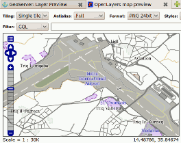
The recipe

  1. Prepare one or more host machines for the database and geographic services.
  2. Prepare your PostgreSQL database and configure it with PostGIS.
  3. Set up your GeoServer and connect it to a PostGIS data source.
  4. Create a web page with the OpenLayers widget to display data from your GeoServer.
  5. Install Java 6 JDK also on the machine where you plan to run OSM2PostGIS. Include the PostgreSQL JDBC4 driver and the PostGIS JDBC extension.
  6. Get a small excerpt of OSM data for your testing. (Don't start with the full planet!)

Then see if you can get the latest release of OSM2PostGIS to work. Please send your feedback about all the steps you needed to take. Your input is much appreciated and it will be used to make better documentation.

Components

OSM2PostGIS relies on several open source software components, and there is always a community behind each of these pieces of technology. The names of the components and their origins are as follows:

OpenStreetMap by OSM Foundation

"A rights-free map of the world being created by volunteers using copyright free sources and GPS tracks."

PostgreSQL by PostgreSQL Global Development Group

"Sophisticated open-source Object-Relational DBMS supporting almost all SQL constructs, including subselects, transactions, and user-defined types and functions."

PostGIS by Refractions Research

"PostGIS is a project which adds support for geographic objects in PostgreSQL, allowing it to be used as a spatial database for geographic information systems (GIS)."

pgRouting by Orkney, Georepublic, Camptocamp

"The pgRouting project provides routing functionality to PostGIS / PostgreSQL as open source software."

GeoServer by OpenGeo, Refractions Research, Axios, GeoSolutions, et al.

"GeoServer is an open source software server written in Java that allows users to share and edit geospatial data. Designed for interoperability, it publishes data from any major spatial data source using open standards."

OpenLayers by MetaCarta, OSGeo Foundation

"OpenLayers is an open source JavaScript library for displaying map data in web browsers."

Get the source code

You can check out the latest OSM2PostGIS source code from the Subversion repository:

svn co https://osm2postgis.svn.sourceforge.net/svnroot/osm2postgis/trunk osm2postgis

Recent source code is also available as a compressed archive file. See the Download section.